
A day doesn’t go by when I am not scouring weather forecast apps checking to see if there is any hint of mist or fog on the horizon.
Why though? Why do we landscape photographers love the fluffy stuff so much? What makes mist so special for photography?
Misty photography
I love the way mist simplifies a scene. Whether it is standing up a hill on a chilly morning, looking down on a cloud inversion, with trees and a church poking through the mist, wandering through thick fog in the city at night, seeing ethereal lights and shapes creeping through, or catching misty rays of light break through trees in a wood, it is a photographer’s dream.
A hidden landscape
Fog reduces visibility, reduces contrast and reduces saturation. Mist wraps a scene in a blanket, allowing isolated subjects to break through. It is the combination of all these things which turn what would be an ordinary view into something extraordinary.
The reduced visibility softens a view. Imagine a chaotic woodland on a clear day, or a busy city street – it is hard to pick out a single subject and there are often too many elements present to make for a pleasing image. Mist or fog will completely change the scene. It is basically cheating!
I love how even a mundane city view can be turned into something otherworldly on a foggy morning.
So let’s get into the technicalities of what causes mist and fog to form. What exactly is mist? Is it the same thing as fog? Why does it happen?
To get to the bottom of this, and how mist makes great photos, we need to first understand exactly what it is.
What is mist? What is fog? How do they form?
Mist and fog are effectively a cloud but at ground level. They are the suspension of water droplets in the air, and it is these droplets which reduce visibility.
For fog or mist to form, the air must cool enough to reach the point that the moisture in it condenses to form tiny droplets (this is known as the dew point). The air needs to be saturated for this to happen. When air is too saturated and can no longer hold any more water, this invisible water vapour condenses to form tiny droplets that are suspended in the air.
The higher the humidity, the more saturated the air is, and the more likely it is that water droplets will form. The more droplets of water in the air there are, the foggier it is.
Another way to think of it – imagine tiny molecules of water in the air zooming around. As the temperature cools, these will start to slow down. If the air is particularly humid – saturated – there are lots more of them to bump into and clump together. As a result, these will form droplets of water and they are small enough to stay hanging in the air. This is fog. If it’s too windy, they’ll spread out and the fog will disappear. If there’s no wind, they’ll sink – if it’s a gentle breeze, they will stay in the air.
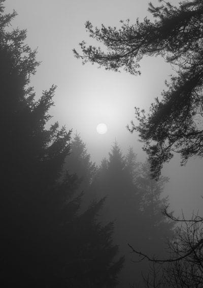
The light passing through these droplets of water is reflected or refracted, which reduces visibility. Looking back at the sun through fog, you can often see a pale white circle – the light from the sun is diffused and scattered – instead of a single sharp source of light, it is softer and more spread out.
There are a few different ways that mist can form, which I will outline below.

What is the difference between mist and fog?
The difference between mist and fog is simply the visibility. It is the degree of visibility which differentiates them.
If visibility is 1,000m (1km) or less, then it is called fog. For driving purposes, it is called fog if visibility is less than 100m.
If visibility is reduced, but greater than 1,000m (1km), then it is called mist.
It sounds pretty technical – but once you come face to face with fog, you know full well what you are looking at (or not, if it’s super foggy…). I have driven in severely foggy conditions before, and it is not a pleasant experience. Some foggy mornings have had visibility reduced to just a few metres, which can make travelling particularly treacherous. Extremely reduced visibility can make for some pretty spectacular images though.

What types of fog are there?
Radiation fog
Look out for calm, clear nights with low wind and ground that has been saturated by rainfall during the day or so before.
Radiation fog happens (usually during the night) when the heat absorbed by the land during the day is radiated into the atmosphere (which happens more easily during a clear night), causing the air close to the surface to cool. With a cooler temperature, this reduces the ability of the air to hold its own moisture – condensation then results once the dew point has been reached (this is the temperature below which droplets of water form in the air).
This generally occurs during the cooler months of the year, so primarily Autumn and Winter. It is not always though – I’ve had plenty of Spring sunrises with mist, and in the Summer too.
As the sun rises, the mist starts to burn off. Radiation fog is the one most photographers will be looking for. It is the thin layer of mist over fields on a crispy Winter morning.
Valley fog
This occurs when cold, dense air forms at the bottom of a valley. It is often as a result of a temperature inversion (increasing air temperature with height), when warm air passes over the valley beneath. The Wye Valley is a perfect example of this, and you can often find a river of mist running along here, particularly in the colder months.
Advection fog
This happens when a warm layer of moist air passes over a cold area. This can often happen at sea.
Upslope fog
This occurs when wind blows air up a slope, cooling as it progresses, allowing moisture to condense to form fog.
Evaporation fog
This happens when colder air passes over warmer water. The water evaporates, resulting in a layer of warmer air, which mixes with the cooler air, cools and then condenses.

When is the best time of year for mist and fog?
Autumn and Winter are generally the best time of year to find mist, as the cooler air allows more chance for the dew point to be reached during the night. The shorter nights of Summer offer less chance for the air to cool sufficiently. One of the best mornings I’ve experienced was in June, so nothing is a given!

Where are the best locations in the UK for mist and fog?
We often complain about soggy weather here in the UK, however our often damp, temperate climate makes it the perfect place for mist and fog to develop. Here are some of my favourite local misty locations:
Somerset Levels – is there a more saturated part of the UK than the Levels? If conditions are mist-friendly, it will be misty here
Wye Valley – a river running through a deep valley, surrounded by acres of woodland. It’s prime territory for mist to form
Priddy Pools – I love Stockhill Wood in the Mendips. In front of it sits a marsh patch of land which always seems to have mist.
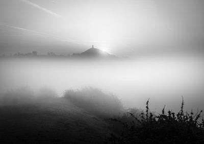
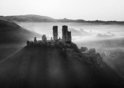
Corfe Castle – it’s top of most landscape photography bucket lists, but you would be hard pressed to find a more photogenic misty location than here.
Dartmoor – is there a more atmospheric location in the ok? Unlikely. Dartmoor is an incredible location for photography, and it has a good dollop of mist and fog to go with it.
I’d love to hear more misty favourite locations – please drop a comment below so I can add them on.

How to predict mist and fog
Keep a close eye on the forecast. Here are the main things to look out for:
- Cool, clear nights
- Low wind speed
- Precipitation in the day or so before
- A calm forecast for the morning – not too much low cloud
- High humidity – I find anything above 95% gives a great chance
The best apps for predicting mist
I have many, many weather apps. They rarely agree, so I always like to see if there is a hint of consensus.
- Met Office – they’re the best UK app for weather forecasts, and generally get it right more than any other. It is lacking in extra detail though. Look at the humidity, wind speed and particularly the visibility in the early hours.
- ClearOutside – this is a great app, with a dedicated fog forecast and separate cloud levels. The UI is lacking though and it can be a little buggy (fog levels can glitch).
- Ventusky – this is my new favourite weather app. It is incredibly detailed, but most importantly, it has a fog map. The premium version lets you switch between different forecast models, which include the Met Office amongst them. The fog map lets you see regional predictions, which can be pretty useful. The website version is free to use.
- Windy – very similar to Ventusky, although a little more chaotic to navigate. It is incredibly detailed. The website version is free to use.
- Yr – a brilliant Norwegian weather app. I’ve found it pretty reliable.
- BBC Weather – I find it a bit hit and miss and seems to show cloud more than any other app.
- XCWeather – this is a website, however you can save as an app from the browser. It’s great for a visual representation of current conditions.
- MWIS – Mountain Weather Information Service. If you’re going up a mountain, check here first.

Signs for mist and fog
Look for signs of reduced visibility in the morning. The MetOffice is a great starting point for forecasts – they will often show mist, and if not, look at the visibility. They also provide a summary of what to expect overnight. If you step outside at night and it’s totally clear and feels cool, make sure to charge your camera.
Mist is notoriously difficult to predict, and many, many times have multiple forecasts predicted mist, only for me to arrive at a destination to find none at all.
Don’t despair if the weather apps don’t show mist. It’s worth bearing in mind that no weather app shows localised mist. When I say localised, I don’t mean at a city scale, but one that is tens of metres in scale. I have a few locations I know of that are prone to mist – but only in isolated pockets. These won’t ever show up on weather forecasts, however I look out for the conditions that make them more likely to appear.
How to photograph mist and fog
I absolutely love a good misty morning. However, I also find them incredibly stressful as well – it’s my favourite kind of morning and I hate missing images and opportunities. So there are a few things to remember and to be aware of.
Condensation
If you’re in fog, be aware of condensation. Keep a microfibre cloth handy, and check every now and then to make sure your lens hasn’t misted up. You will find temperature differences can be extreme on a cold foggy morning, and this temperature difference will see condensation building up on your glass. If you take your camera from a warm heated car straight out into a freezing cold foggy field, the lens will fog up – you need to let your camera bag sit in the cool conditions for a bit so your gear is closer to the temperature outside. This isn’t easily done of course, so make sure to keep that cloth handy.
Charge those batteries
Batteries drain quicker in the cold, so make sure your camera and drone batteries (if you use a drone) are charged ready. I make sure to keep my gear topped up every few days – you never know what’s on the horizon (see also aurora photography…).
Research locations
Make sure to research locations. What is the topography like? Have you seen photos of mist there before, and if so, where was it? It is a hell of a lot harder getting to a spot when there’s thick fog. Know where you’re going.
Planning for mist
If you’re not familiar with a location, take a look on Google and see if you can predict where mist might be present. Is there a water source – or a valley? If you’re hoping for a cloud inversion, then make sure you’ve found a good elevated position to get above it. Google Earth can be a great tool. Have back-up locations – if you’re after an inversion and the mist is too high, think about where is higher!
Photo planning apps
I use Sun Surveyor and PhotoPills. They’re both brilliant and let you plot a photo in advance, including the position of the sun. Sun Surveyor has a Google Streetview feature which is brilliant.
Get up earlier than usual
Set your alarm nice and early. If it’s foggy, it is going to take you longer to get to your destination. I always aim to get to my target location 45 minutes before sunrise – plot the journey time to here, and then add on 30 minutes just in case. Summer sunrise missions can be an exhausting experience!
Pack a tripod
With less light making it through the fog, your camera will also have less light to work with, so you will need longer shutter speeds. If it is before or just after sunrise, make sure to take a tripod with you. If you don’t have one, or have forgotten it, don’t despair – just set your iso to a higher number (or increase the upper auto level). Make sure to use the histogram on your camera – ensure you don’t under or overexpose.
I fine auto white balance can go haywire in fog or above an inversion – so keep an eye on this, and adjust it if necessary.
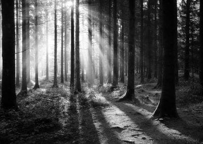
Capturing misty rays
Get into the mist – drive into it! You want thinning mist and a sunny sky. Find a tree and move so the sun is slightly behind the tree – as the mist thins, and if you are lucky, you will see misty rays of light, as the light is scattered. In Japan, they have a word for this – komorebi. My favourite word.
Fogbows, broCken spectres, GLORIES and inversions
I love a cloud inversion. Clambering up a hill through thick fog before finally breaking through to reveal a clear sky above and a blanket of mist ahead – it’s an incredible thing to witness. There is a point where there is still mist, but the sun is starting to break through. It is here where you can witness a fogbow – a foggy equivalent of a rainbow!
If you stand with the sun directly behind you, you may also find a ghostly figure appear directly in front of you – this is called a brocken spectre. Your shadow is being projected upon the mist ahead of you. You will likely see rainbow-like rings directly around your shadow – these are called glories. Then around the very edge, much further out, you may also see a fogbow.
Get out there!
The most important one of all? Go out. Don’t wait for the forecasts to be perfect – they rarely are, and the time the conditions are perfect will no doubt not have been predicted. It’s more important to get out there as often as you can. I’ve lost count of the number of times I’ve been asked by people why I always seem to get so many misty photos. It is simply because I just get out there! If conditions aren’t perfect, at least it gives you a chance to find a composition which could work in the future.
Follow me on Instagram
That’s right, if you want to crack mist and fog photography, you really need to er, follow me on Instagram. Trust me, you won’t regret it…
Show me your photos!
If you use this guide, please don’t forget to give me a shout out when you post any photos, I’d love to see what you capture!
Let me know what you think
I hope this article has been helpful. I’d love to hear your thoughts on mist, where you’ve seen it, why you like it, what you’d like to see, and any other thoughts you have!
Updated 5th January 2025, adding new forecast links and options.

Looking for fine art mist prints?
I have a range of fine art photo prints of mist. Please take a look around my print shop. Here are a few – check out the Mist and Fog category in my Print Shop for much more.

I’d love to hear your thoughts on mist and fog – where are your favourite locations?
Wow Sam! So informative, never knew that must and fog could be so interesting! I will never look at them in the same way again!
thank you so much Bev! You’re my first ever blog commenter 🙂
Really useful, just what I was looking for. Thanks
Thanks Jackie, that’s great to hear!
And here’s another Bev and I used to.live in Bristol. Very passionate photographer and love your very impressive images and the sharing of useful information eg fog which I took photos in and around Boston, uk yesterday. Definitely will.watch this space!
Thank you so much Bev, that’s awesome! It looked like amazing foggy conditions across the country the last few days. A nice end to the year!